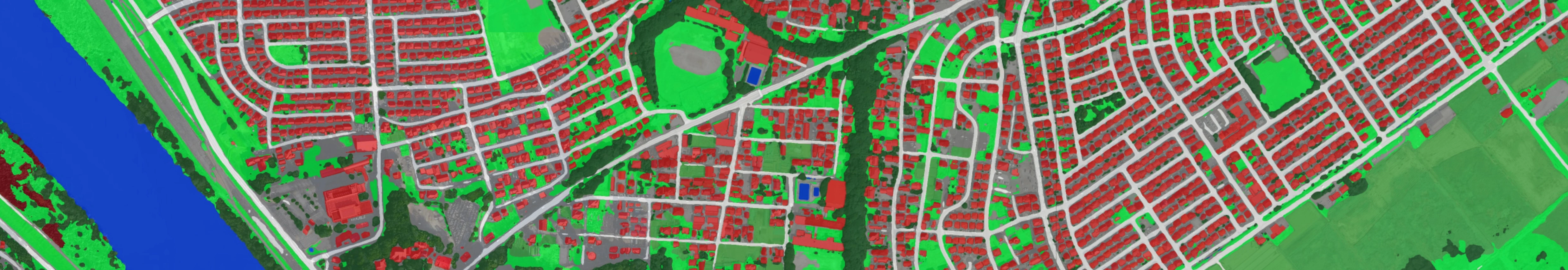
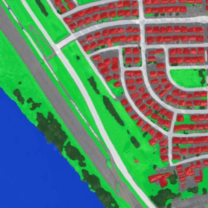
On July 4, 2020, torrential rains hit Kyushu, Japan, triggering floods and landslides. The Geoinformatics Unit, RIKEN Center for Advanced Intelligence Project conducted a preliminary mapping of the affected areas using ALOS-2 data provided by JAXA through Sentinel Asia.
Pleased to announce that our paper has been accepted to ECCV 2020 as spotlight!
Our paper entitled "Hyperspectral Image Compressive Sensing Reconstruction Using Subspace-based Nonlocal Tensor Ring Decomposition" led by Yong Chen, who was an intern at the Geoinformatics Unit, has been published in IEEE Transactions on Image Processing.
Our paper entitled "Robust nonlocal low-rank SAR time series despeckling considering speckle correlation by total variation regularization" led by Gerald Baier has been published in IEEE Transactions on Geoscience and Remote Sensing.
Our two proposals were accepted for KAKENHI Grant-in-Aid for Young Scientists, Japan Society for the Promotion of Science (JSPS).
Our paper entitled "A Semiautomatic Pixel-Object Method for Detecting Landslides Using Multitemporal ALOS-2 Intensity Images" led by Bruno Adriano has been accepted for publication in Remote Sensing.
Our paper entitled "Illumination invariant hyperspectral image unmixing based on a digital surface model" written by Tatsumi Uezato, Naoto Yokoya, and Wei He has been accepted for publication in IEEE Transactions on Image Processing.
Pleased to announce that our paper entitled "Data fusion-based spectral unmixing with spectral variability" written by Tatsumi Uezato, Naoto Yokoya, and Wei He has been selected for the best presentation award at the 67th Autumn Conference of the Remote Sensing Society of Japan (RSSJ).
On October 12, 2019, the Typhoon Hagibis hit East Japan, triggering floods and landslides. The Geoinformatics Unit, RIKEN Center for Advanced Intelligence Project conducted a preliminary mapping of the affected areas using Sentinel-1 SAR data provided by ESA.
On August 26, 2019, torrential rain hit Laos, triggering floods. The Geoinformatics Unit, RIKEN Center for Advanced Intelligence Project conducted a preliminary mapping of the affected areas using earth observation data. The Sentinal Asia Program provided ALOS-2 PALSAR-2 data used in this analysis.
Our paper entitled "Blind Cloud and Cloud Shadow Removal of Multitemporal Images Based on Total Variation Regularized Low-Rank Sparsity Decomposition" written by Yong Chen, Wei He, Naoto Yokoya, and Ting-Zhu Huang has been accepted for publication in ISPRS Journal of Photogrammetry and Remote Sensing.
On August 28, 2019, torrential rain hit Saga Prefecture, Japan, triggering floods and landslides. The Geoinformatics Unit, RIKEN Center for Advanced Intelligence Project conducted a preliminary mapping of the affected areas using earth observation data. The Sentinal Asia Program provided ALOS-2 PALSAR-2 data used in this analysis.
Early August 2019, the Southwest monsoon hit Myanmar flooding several areas. The Geoinformatics Unit, RIKEN Center for Advanced Intelligence Project conducted a preliminary mapping of the affected areas using earth observation data. The Sentinal Asia Program provided the high-resolution ALOS-2 PALSAR-2 data used in this analysis.
Our paper entitled "Hyperspectral Image Restoration Using Weighted Group Sparsity Regularized Low-Rank Tensor Decomposition" written by Yong Chen, Wei He, Naoto Yokoya, and Ting-Zhu Huang has been accepted for publication in IEEE Transactions on Cybernetics (TCYB).
Our paper entitled "Remote sensing image reconstruction using tensor ring completion and total-variation" has been accepted for publication in IEEE Transactions on Geoscience and Remote Sensing (TGRS).
On May 16, 2019, a major slump landslide occurred at Aybasti, Turkey. The Geoinformatics Unit, RIKEN Center for Advanced Intelligence Project conducted preliminary mapping of the affected areas using earth observation data. The ALOS-2 PALSAR-2 data used in this analysis was acquired through the Sentinel Asia Program.
On early May 2019, the Cyclone Fani hit the central east coast of India flooding several areas.
On 22 April 2019, an M 6.1 earthquake struck the Philippines at 5:11 pm (local time).
Our two proposals were accepted for the 2nd Research Announcement on the Earth Observations (EO-RA2) coordinated by JAXA.
Torrential rain in late March 2019 hit the northern part of Iran causing extensive flooding in urban areas and surroundings.
The first heavy rain hit Northern Iran on 21st March 2019, and the second one hit southern and central Iran after just a few days. According to the authorities, most of the people in Pol-e Dokhtar town in Lorestan province were trapped in balconies and rooftops due to the huge amount of water on the streets.
Our two proposals were accepted for KAKENHI Grant-in-Aid for Young Scientists, Japan Society for the Promotion of Science (JSPS).
Torrential rain on 21 March 2019 hits the northern part of Iran, leaving local people homeless in the Golestan province. Although the capital of the Golestan province (Gorgan city) is situated too far from the inundated area, Aqqala town has been seriously affected.
On late January 2019, extensive damage occurred due to the collapse of a tailings dam in Brazil.
Pleased to announce that two papers were accepted to CVPR 2019, Long Beach, CA.
Pleased to announce that two papers were accepted to IEEE ICASSP 2019, Brighton, UK.
On September 28, 2018 (10:02:43 UTC), an M7.5 earthquake occurred 8km North of Palu, Indonesia, causing a tsunami with waves up to 2 m.
Submission for the special stream "Advanced Processing for Multimodal Optical Remote Sensing Imagery" of IEEE Geoscience and Remote Sensing Letters is open since October 1, 2018.
On September 28, 2018 (10:02:43 UTC), an M7.5 earthquake occurred 8km North of Palu, Indonesia, causing a tsunami with waves up to 2 m.
Our paper entitled "Multi-temporal Sentinel-1 and -2 data fusion for optical image simulation" has been published in ISPRS International Journal of Geo-Information.
On September 15, 2018, the Typhoon Mangkhut caused extensive flooding in the northern region of the Philippines. The Geoinformatics Unit from RIKEN Center for Advanced Intelligence Project conducted a preliminary mapping of the flooded areas using satellite remote sensing imagery.
On September 6, 2018, an M6.7 earthquake occurred in the Hokkaido region, eastern Japan, causing severe damage and casualties. The Geoinformatics Unit from RIKEN Center for Advanced Intelligence Project, Tokyo Institute of Technology, and the International Research Institute of Disaster Science conducted a preliminary damage mapping using satellite remote sensing imagery (ALOS-2) acquired from the affected areas.
On August 29, 2018, extensive flooding occurred due to the collapse of the Swar Irrigation Dam in southern Myanmar.
On July 6, 2018, severe damage and causalities occurred due to the torrential rain in western Japan. The Geoinformatics Unit from RIKEN-AIP and the International Research Institute of Disaster Science (IRIDeS) conducted a preliminary damage mapping using satellite remote sensing imagery (ALOS-2) acquired from the affected areas. The ALOS-2 data used in this analysis was provided by the large-scale disaster satellite image analysis support team of the National Aerospace Exploration Agency of Japan.
RIKEN Center for Advanced Intelligence Project Nihonbashi 1-chome Mitsui Building, 15th floor 1-4-1 Nihonbashi, Chuo-ku Tokyo 103-0027, Japan |
|
+81-48-467-3626 | |
(first name).(last name)riken.jp |